
Are you looking for the CBSE Class 12 Geography 2024 Topper’s Answer Sheet? In this post, we provide the official question paper and the topper’s answers, helping you understand the perfect way to write answers in the board exam. If you want to score full marks in Geography, analyzing topper’s answers is a great way to improve your presentation, structuring, and content accuracy.
Why Should You Refer to the CBSE Class 12 Geography Topper’s Answer Sheet?
- ✅ Understand Answer Presentation – Learn how toppers structure their responses for better clarity.
- ✅ Identify Key Points – See the exact points that fetch maximum marks.
- ✅ Improve Map Work & Diagrams – Learn the correct way to label and draw maps/diagrams.
- ✅ Follow Word Limits – Know how much to write for different types of questions.
- ✅ Boost Time Management – Observe how toppers maintain speed and accuracy.
How to Write Answers Like a Topper?
If you want to score 95+ marks in Geography, follow these tips inspired by topper’s answer sheets:
1️⃣ Stick to NCERT Content
CBSE strictly follows NCERT. Ensure your answers are NCERT-based and avoid unnecessary details.
2️⃣ Use Bullet Points for Theoretical Answers
Avoid lengthy paragraphs. Use bullet points for better readability.
3️⃣ Master Map Work
Always practice map-based questions. Label neatly and use a sharp pencil for clarity.
4️⃣ Include Relevant Diagrams
Many answers require diagrams. Even if not explicitly asked, adding diagrams can improve your score.
5️⃣ Follow Proper Formatting
- Start with an introductory sentence
- Use headings and subheadings
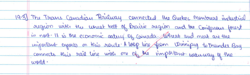
- End with a conclusion, if required
CBSE Class 12 Geography 2024 Topper’s Answer Sheet: Question Paper and Answers
General Instructions:
Read the following instructions carefully and follow them:
- This question paper contains 30 questions. All questions are compulsory.
- The question paper is divided into five sections – Sections A, B, C, D, and E.
- Section A – Questions no. 1 to 17 are Multiple Choice Type questions. Each question carries 1 mark.
- Section B – Questions no. 18 and 19 are Source-based questions. Each question carries 3 marks.
- Section C – Questions no. 20 to 23 are Short Answer Type questions. Each question carries 3 marks. Answers to these questions shall be written in 80 to 100 words.
- Section D – Questions no. 24 to 28 are Long Answer Type questions. Each question carries 5 marks. Answers to these questions shall be written in 120 to 150 words.
- Section E – Questions no. 29 and 30 are Map-based questions. Each question carries 5 marks.
- In addition to this, a separate question has been provided for Visually Impaired candidates in lieu of questions having visual inputs, maps, etc. Such questions are to be attempted by Visually Impaired candidates only.
- There is no overall choice given in the question paper. However, an internal choice has been provided in a few questions in all sections other than Section A.
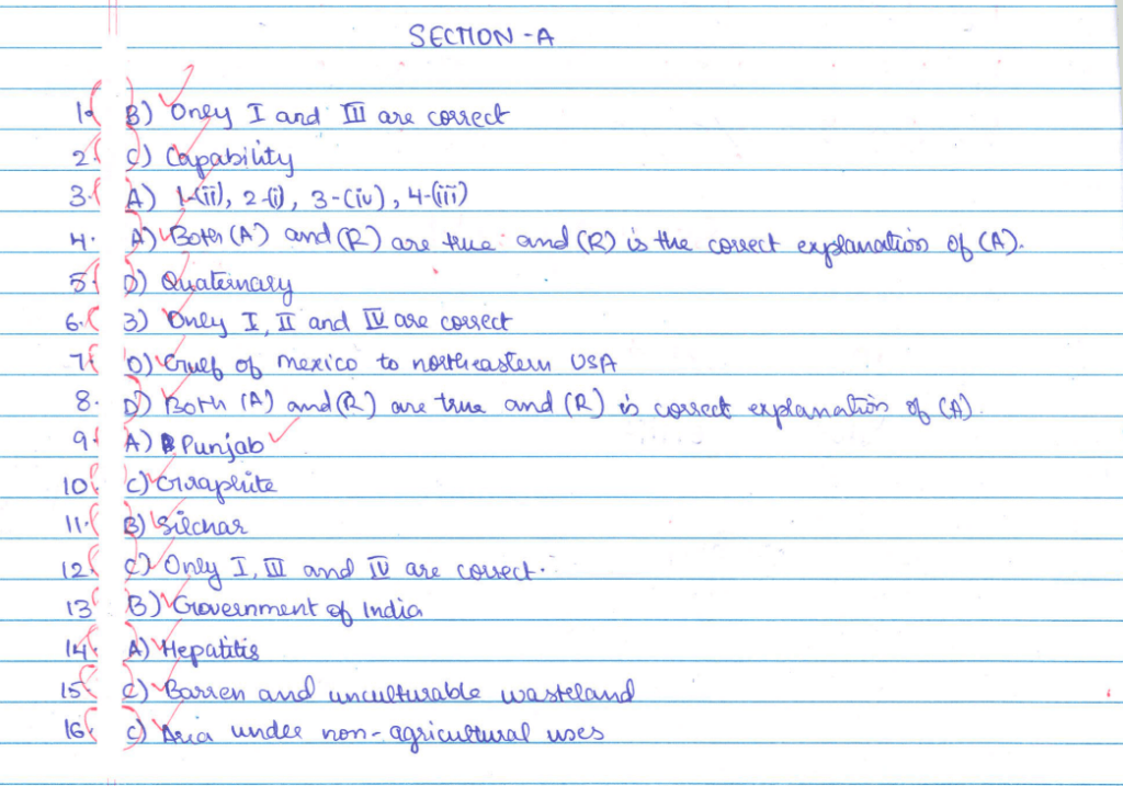
SECTION A
Questions no. 1 to 17 are Multiple Choice Type Questions. Each question carries 1 mark.
1. Read the following factors of migration carefully and choose the correct option related to pull factors:
- I. Peace and stability
- II. Unfavourable climate
- III. Protection of property
- IV. Economic backwardness
Options:
(A) Only I and II are correct.
(B) Only I and III are correct.
(C) Only II and IV are correct.
(D) Only II and III are correct.
2. Which one of the following is an approach of Human Development?
(A) Equity
(B) Productivity
(C) Capability
(D) Empowerment
3. Match Column I with Column II and choose the correct option:
| Column I (Area) | Column II (Animal Domestication) |
| 1. Tropical Africa | (i) Camel |
| 2. Asiatic Deserts | (ii) Cattle |
| 3. Mountainous areas of Tibet | (iii) Reindeer |
| 4. Sub-Arctic areas | (iv) Llamas |
Options:
(A) 1-(ii), 2-(i), 3-(iv), 4-(iii)
(B) 1-(i), 2-(ii), 3-(iv), 4-(iii)
(C) 1-(ii), 2-(i), 3-(iii), 4-(iv)
(D) 1-(i), 2-(ii), 3-(iii), 4-(iv)
4. Two statements are given below. They are Assertion (A) and Reason (R). Read both the statements carefully and choose the correct option:
Assertion (A): Foot loose industries can be located in a wide variety of places.
Reason (R): The important factor in the location of foot loose industries is accessibility by transport network.
Options:
(A) Both (A) and (R) are true and (R) is the correct explanation of (A).
(B) Both (A) and (R) are true, but (R) is not the correct explanation of (A).
(C) (A) is true, but (R) is false.
(D) (A) is false, but (R) is true.
5. Production of information is related to which one of the following sectors?
(A) Primary
(B) Secondary
(C) Tertiary
(D) Quaternary
6. Read the following characteristics of retail trading carefully and choose the correct option:
I. This is concerned with the sale of goods directly to the consumers.
II. Most of the retail trading takes place in fixed establishments or stores.
III. It is formed by many middlemen, traders, and suppliers.
IV. Hawkers, street peddling, automatic vending machines, etc. are its examples.
Options:
(A) Only I, II, and III are correct.
(B) Only I, II, and IV are correct.
(C) Only II, III, and IV are correct.
(D) Only I, III, and IV are correct.
7. Which one of the following is known as the ‘Big Inch’ pipeline?
(A) Iran – India via Pakistan
(B) Iran – China via Afghanistan
(C) Hazira – Vijaypur to Jagdishpur
(D) Gulf of Mexico to northeastern USA
8. Two statements are given below. They are Assertion (A) and Reason (R). Read both the statements carefully and choose the correct option:
Assertion (A): Countries need to be cautious about dumped goods under free trade.
Reason (R): Dumping of goods can harm the domestic producers. Options:
(A) (A) is true, but (R) is false.
(B) (A) is false, but (R) is true.
(C) Both (A) and (R) are true, but (R) is not the correct explanation of (A).
(D) Both (A) and (R) are true and (R) is the correct explanation of (A).
9. Choose the correct option to fill in the blank:
The groundwater utilization is very high in ______. If the present trend of groundwater utilization continues, it would be very difficult to meet the water needs.
(A) Punjab
(B) Odisha
(C) Kerala
(D) Chhattisgarh
10. Choose the correct option to fill in the blank in the flow chart:
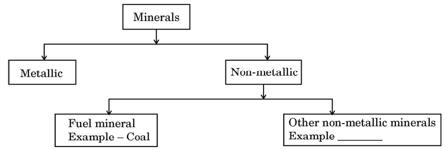
Options:
(A) Gold
(B) Bauxite
(C) Graphite
(D) Manganese
11. Which one of the following places is the easternmost station of the ‘East-West Corridor’?
(A) Digboi
(B) Silchar
(C) Guwahati
(D) Itanagar
12. Read the programmes related to the proposed Bharatmala umbrella scheme carefully and choose the correct option:
- I. Backward areas, religious and tourist places connectivity programme
- II. To interconnect the four metropolitan cities of the country
- III. To develop State roads in adjoining coastal areas
- IV. To connect non-major ports in coastal states
Options:
(A) Only I, II, and III are correct.
(B) Only II, III, and IV are correct.
(C) Only I, III, and IV are correct.
(D) Only I, II, and IV are correct.
13. ‘Swachh Bharat Mission’ has been launched by which one of the following?
(A) Government of Madhya Pradesh
(B) Government of India
(C) Non-Governmental Organisation
(D) World Health Organisation
14. Which one of the following diseases is caused by water pollution?
(A) Hepatitis
(B) Asthma
(C) Pneumonia
(D) Deafness
Study the following diagram carefully and answer Q. No. 15 to 17.
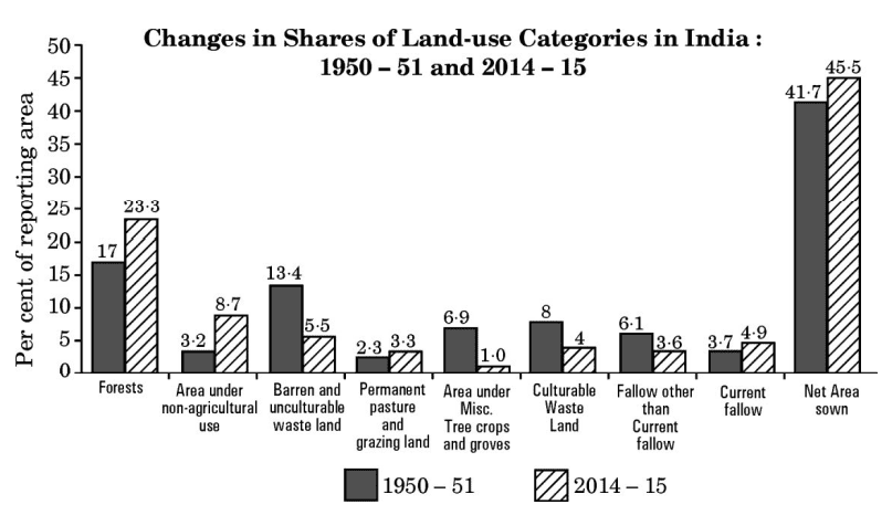
15. In comparison to 1950 – 51, which of the following categories has decreased the most in 2014 – 15?
(A) Forests
(B) Permanent pasture and grazing land
(C) Barren and unculturable wasteland
(D) Culturable wasteland
16. In comparison to 1950 – 51, which one of the following categories has the highest difference of increase in 2014 – 15?
(A) Barren and unculturable wasteland
(B) Net area sown
(C) Area under non-agricultural uses
(D) Current fallow
17. Which one of the following is the correct difference in ‘Net Area Sown’ between 1950 – 51 and 2014 – 15?
(A) 3·6% (of reporting area)
(B) 3·7% (of reporting area)
(C) 3·8% (of reporting area)
(D) 3·9% (of reporting area)
Ans.

SECTION B
Questions number 18 and 19 are Source-Based Questions. Each question carries 3 marks.
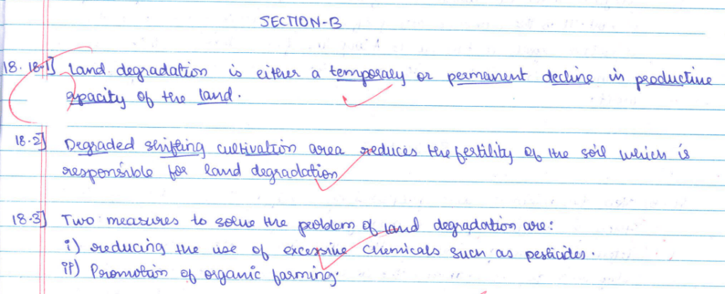
18. Read the given passage carefully and answer the questions that follow:
Land Degradation
The pressure on agricultural land increases not only due to the limited availability but also by deterioration of the quality of agricultural land. Soil erosion, waterlogging, salinisation, and alkalinisation of land lead to land degradation. What happens if land is consistently used without managing its fertility? Land is degraded and productivity declines. Land degradation is generally understood either as a temporary or a permanent decline in the productive capacity of the land.
Though all degraded land may not be wasteland, the unchecked process of degradation may lead to the conversion to wasteland.
There are two processes that induce land degradation. These are natural and created by human beings. The National Remote Sensing Centre (NRSC) has classified wastelands by using remote sensing techniques, and it is possible to categorise these wastelands according to the processes that have created them. There are a few types of wastelands such as gullied/ravinous land, desertic or coastal sands, barren rocky areas, steep sloping land, and glacial areas, which are primarily caused by natural agents. There are other types of degraded lands such as waterlogged and marshy areas, land affected by salinity and alkalinity, and land with or without scrub, which have largely been caused by natural as well as human factors. There are some other types of wastelands such as degraded shifting cultivation area, degraded land under plantation crops, degraded forests, degraded pastures, and mining and industrial wastelands, that are caused by human action.
(18.1) Explain the meaning of ‘land degradation’.
(18.2) Explain any one man-made process which is responsible for ‘land degradation’.
(18.3) Suggest any two measures to solve the problem of ‘land degradation’.
Ans.
19. Study the given map and answer the questions that follow:
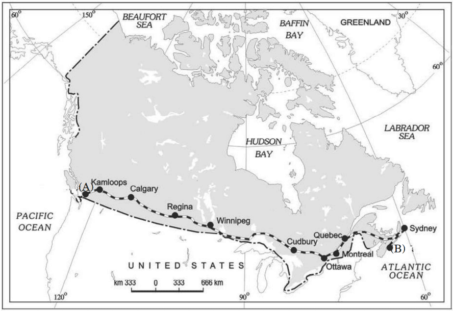
(19.1) Name the railway line given in the map.
(19.2) Name the places marked as ‘(A)’ and ‘(B)’ in the given map.
(19.3) Explain the importance of the railway line given on the map.
Ans.

SECTION C
Questions number 20 to 23 are Short Answer Type Questions. Each question carries 3 marks.
20. (a) How has the use of technology helped people to overcome nature’s obstacles? Analyse.
OR
(b) How does neo-determinism try to achieve balance between two concepts of man-environment relationship? Analyse.
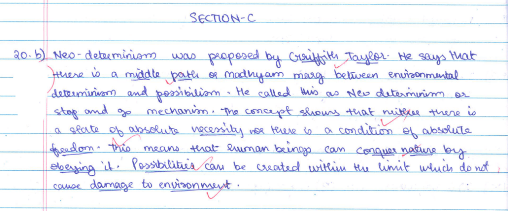
21. Explain, with examples, any three economic factors affecting population distribution in the world.
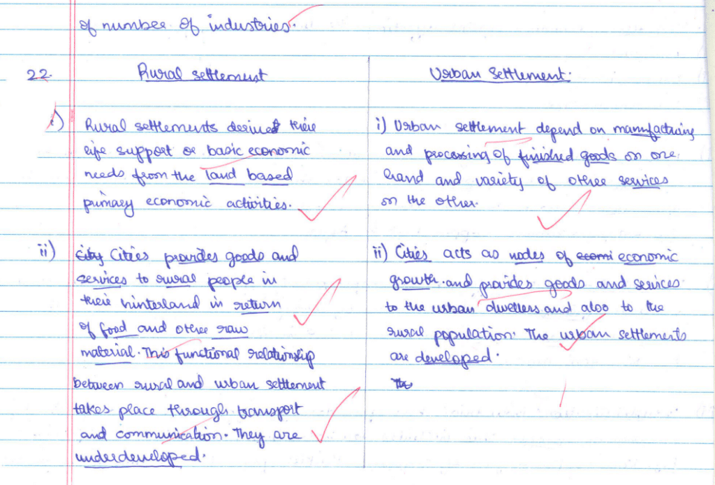
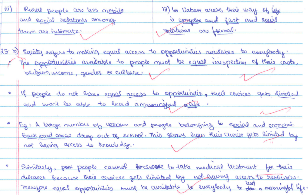
22. Explain any three basic differences between rural and urban settlements in India.
23. (a) “The ways to measure human development are constantly being refined.” Support the statement with suitable arguments.
OR
(b) “Equity refers to making equal access to opportunities available to everybody.” Support the statement with suitable arguments.
Ans.
SECTION D
Questions number 24 to 28 are Long Answer Type Questions. Each question carries 5 marks.
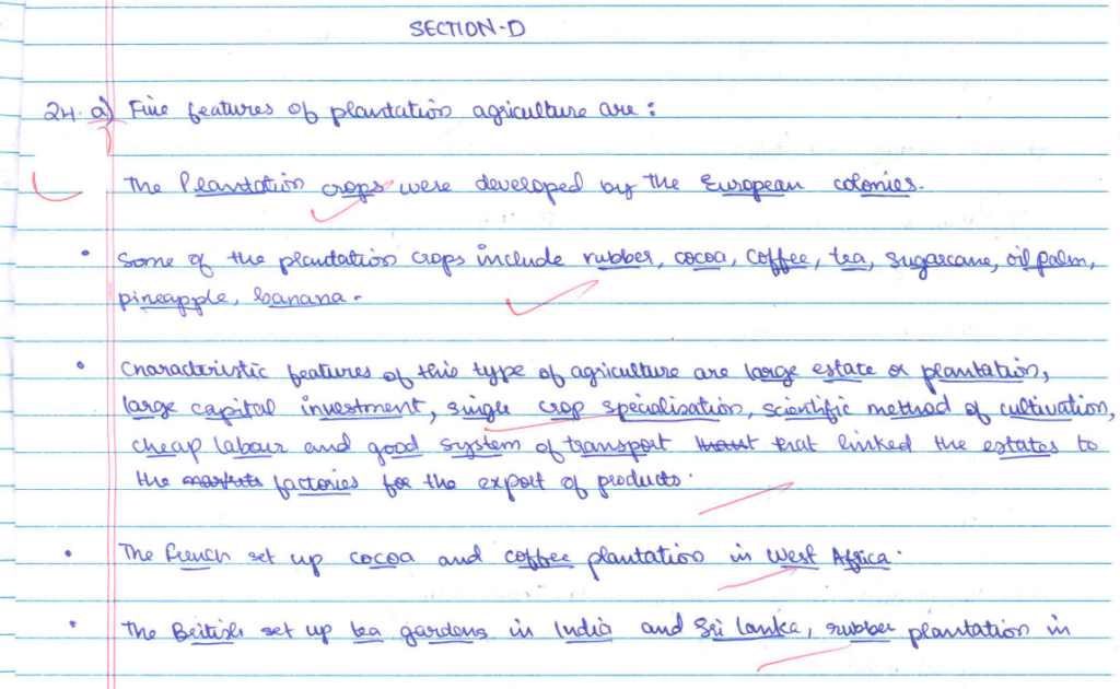
24. (a) Describe any five features of ‘plantation agriculture’ in the world.
OR
(b) Describe any five features of ‘extensive commercial grain farming’ in the world.
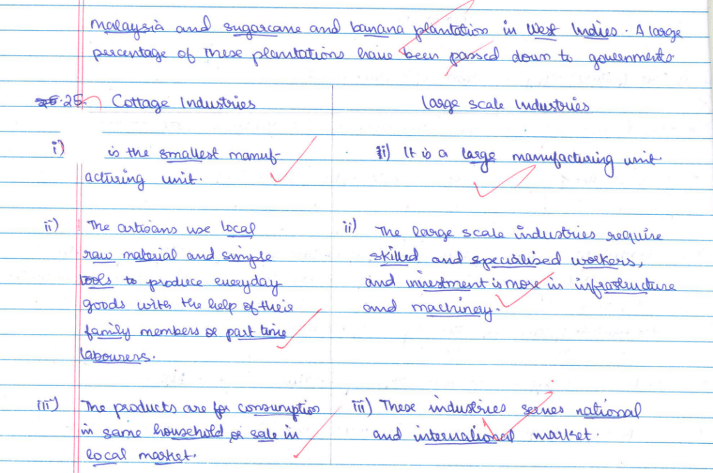
25. Explain the difference between cottage and large-scale industries in the world, with examples.
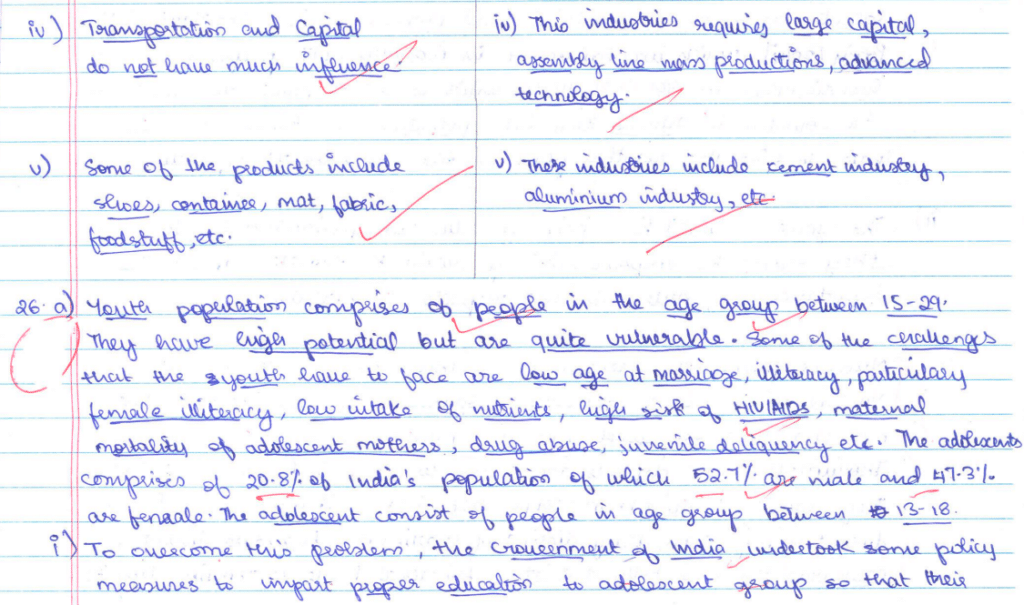
26. (a) Analyse the major problems of youth population in India. Suggest two measures to overcome the problems.
OR
(b) How is discrimination on the basis of gender a crime against humanity? Suggest two measures to overcome the problem.
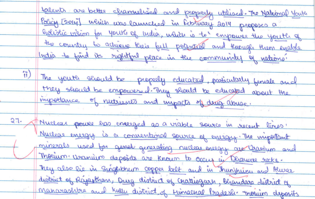
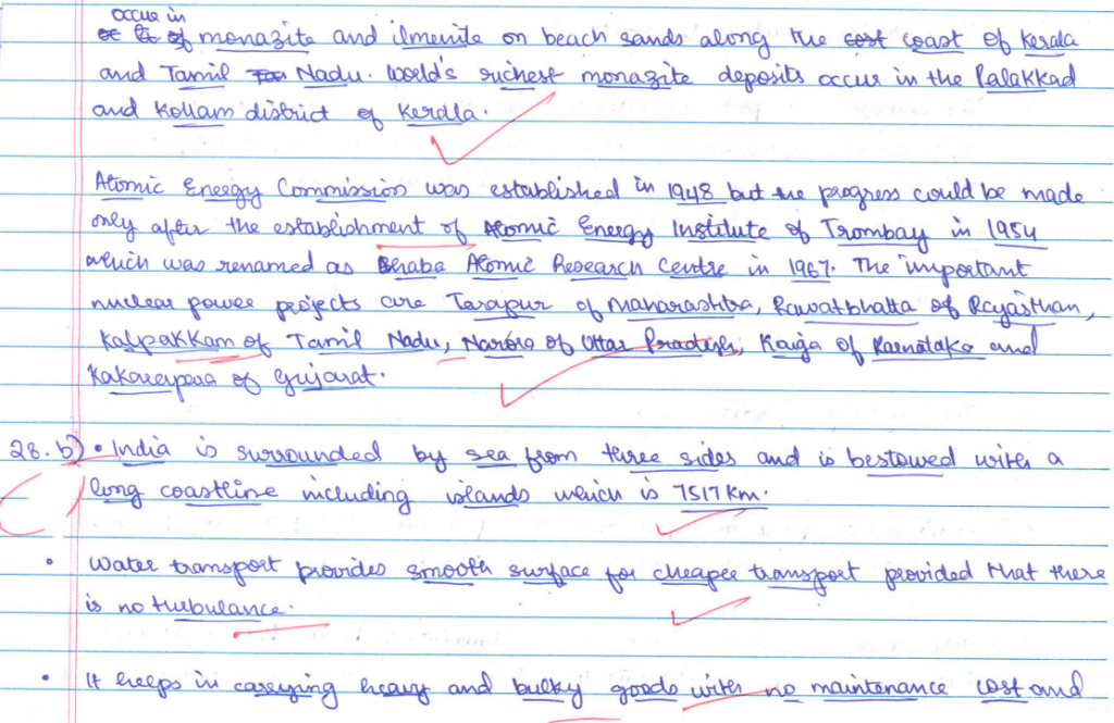
27. “Nuclear power has emerged as a viable source in recent years.” Examine the statement with suitable arguments in the context of India.
28. (a) Explain the importance of rail transport in India.
OR
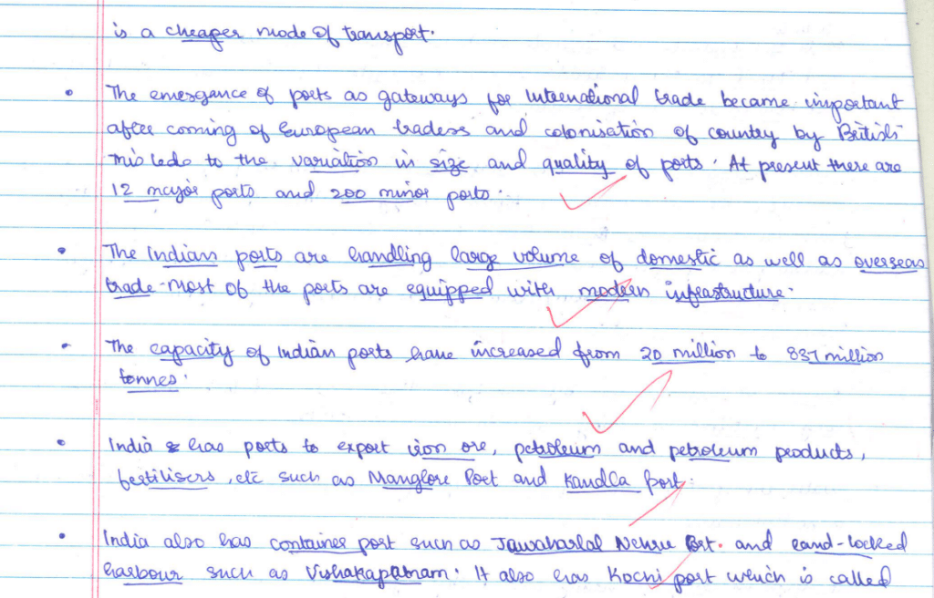
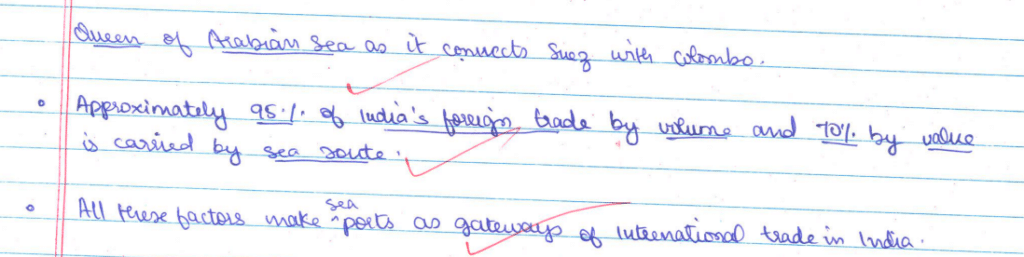
(b) Explain seaport as a gateway for international trade in India.
Ans.
SECTION E
Questions number 29 and 30 are Map-based questions. Each question carries 5 marks.
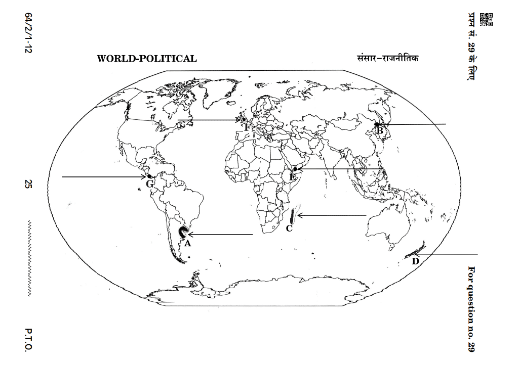
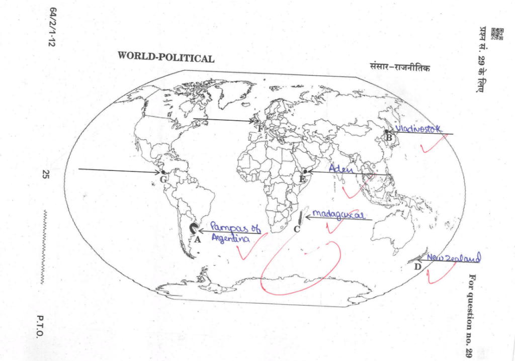
29. On the given political outline map of the World, seven geographical features have been marked as A, B, C, D, E, F, and G. Identify any five with the help of the following information and write their correct names on the lines drawn near them:
A. An area of ‘extensive commercial grain farming’
B. A terminal station of ‘Trans-Siberian Railway’
C. An area of ‘nomadic herding’
D. An area of ‘commercial livestock rearing’
E. A major seaport of Asia
F. A major international airport of Europe
G. A major shipping canal
Ans.
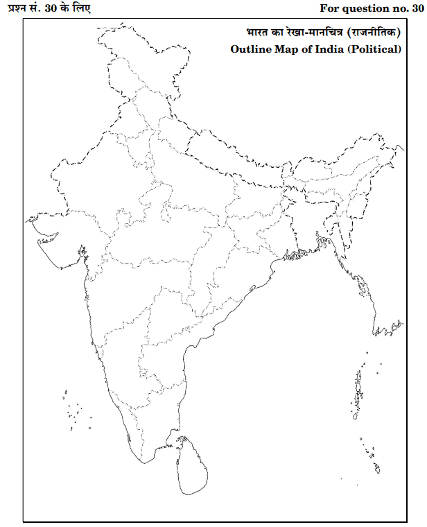
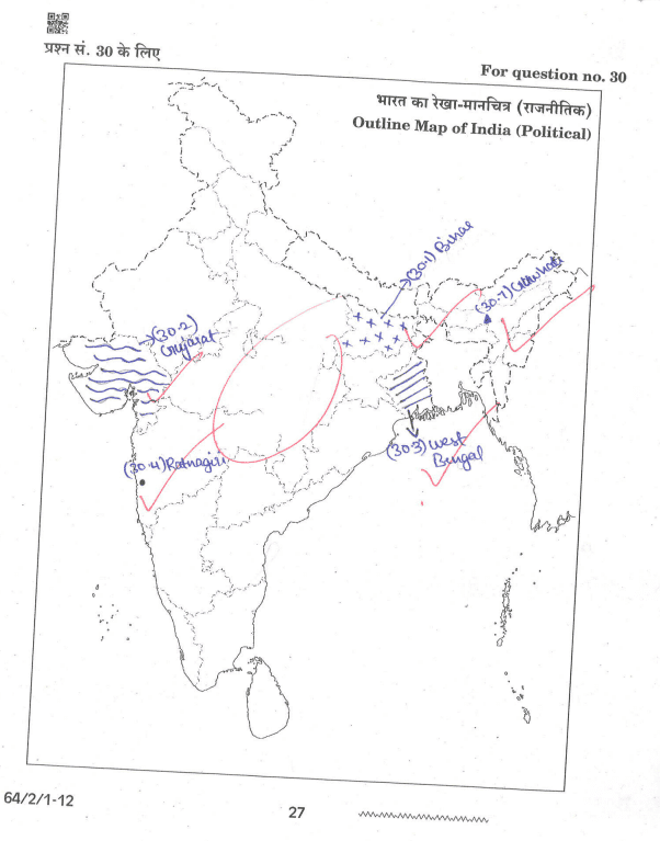
30. On the given political outline map of India, locate and label any five of the following seven geographical features with appropriate symbols:
(30.1) State with the highest density of population
(30.2) State leading in cotton production
(30.3) State leading in rice production
(30.4) Major iron-ore mines of Maharashtra
(30.5) An oil refinery of Uttar Pradesh
(30.6) A major seaport of Odisha
(30.7) An international airport of Assam
Ans.
CBSE Class 12 Geography 2024 Question Paper (Download PDF)
We have provided the official CBSE Geography 2024 question paper in PDF format. Click the link below to download:
🔗 Download CBSE Class 12 Geography 2024 Question Paper
CBSE Class 12 Geography 2024 Topper’s Answer Sheet (PDF)
To help students achieve high scores, we have uploaded the CBSE 12th Geography Topper’s Answer Sheet in PDF format. This answer sheet includes well-structured responses, diagrams, and maps that fetched the highest marks.
🔗 Download CBSE Class 12 Geography 2024 Topper’s Answer Sheet
Most Important Topics for CBSE Class 12 Geography 2024 Board Exam
Based on past years’ trends, here are some of the most important topics:
🔹 Human Geography – Nature & Scope 🔹 Migration – Causes & Consequences 🔹 Population Growth & Distribution 🔹 Primary, Secondary & Tertiary Sectors 🔹 India’s Transport & Communication System 🔹 International Trade & Globalization 🔹 Disaster Management & Sustainable Development
Conclusion
Analyzing the CBSE Class 12 Geography 2024 Topper’s Answer Sheet can significantly improve your preparation. Download the PDFs provided and practice answer writing based on the topper’s strategies.
Stay Updated: Bookmark this page and subscribe to our website for the latest CBSE updates, sample papers, and study materials.
👉 Share this post with your friends preparing for the CBSE Class 12 board exams!
🔗 For more study resources, visit CBSE Guidance